
Tamil Nadu has thrown a surprise this monsoon season with surplus rainfall exceeding 95% of its long-period average, and a huge inflow into the reservoirs filling most of them to the brim.
“Tamil Nadu has not received such a high amount of rain in June-July at least during the last three years. The last time when the southwest monsoon was surplus for the state was perhaps in 2018. This time, especially the interior districts, including those adjacent to the Western Ghats, have witnessed above-normal rains every day since mid-July, while it was still less for coastal areas,” the head of IMD’s Regional Meteorological Centre, Chennai, S Balachandran, told News18.
While the southwest monsoon is known to exhibit such inter-annual variations, the senior meteorologist said, there are always the subsystems whose interplay decides how the monsoon performs. “The state mostly relies on northeast monsoon starting October onwards for rains, but it is good that the southwest monsoon too has been unusually favourable,” he added.
‘Exceptional’
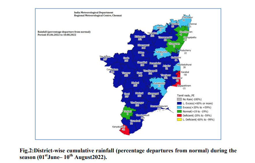
From the onset of monsoon till August 12, Tamil Nadu received 279 mm against the normal of 142.8 mm, which was in excess to the tune of nearly 95%. The monsoon current was vigorous especially over the last week, across 33 of the state’s 40 districts, with 30.4 mm of rain against the normal of 16.1 mm over the last week from August 4-10.
Neighbouring Telangana also witnessed ample rains touching about 791.9 mm against the normal of 428.7mm from 1 June to August 10, which is 85% above the long-period average for the state. On the whole, the southern peninsula has recorded excess rains to the tune of 35% with rain bounty in as many as four subdivisions – Tamil Nadu, south interior Karnataka, and Telangana.
A major reason for this unusual activity has been the monsoon trough – an elongated low-pressure area that normally runs from Ganganagar to Allahabad to head Bay of Bengal. When it is south of its normal position, it brings heavy rainfall over central India and the southern peninsula, and according to the India Meteorological Department, it has been south of its normal position for the most part of July, even till now. The east-west shear zone is also said to have played a critical role.
Chief meteorologist at Skymet Mahesh Palawat cites another significant feature – the series of low-pressure systems that developed over the Bay of Bengal and moved westwards. “It is exceptional this year since the southern states receive such quantity of rain during the northeast monsoon, which starts in October. However, this time, the successive low-pressure systems that developed in the Bay of Bengal, near Odisha and Andhra Pradesh coast, intensified and brought heavy rains as they moved westwards,” he told News18.
Reservoirs full to the brim
Such has been the intensity of rains, that most reservoirs down south are filled to the brim, with more than normal storage available in the basins of Godavari, Krishna, Cauvery, and all other neighbouring east and west-flowing rivers of the south.
Out of the total 40 reservoirs monitored by the Central Water Commission (CWC), nearly 34 are filled to at least 70% of their normal capacity, with storage exceeding that of the last ten years.
Monsoon now shifts to central India
The latest forecast suggests another low-pressure system is in the making in the northwest Bay of Bengal, which is expected to intensify into a deep depression and move west-northwestwards over the next two days. With this, the monsoon is also likely to shift attention to the central states and bring heavy rains for Odisha, Gangetic West Bengal, Madhya Pradesh, Chhattisgarh, and parts of north Maharashtra while rainfall activity gets subdued over the southern states.
Another depression has formed in the northeast Arabian Sea which is expected to intensify into a deep depression by Saturday morning and move westwards. It was located about 470 km west of Porbandar in Gujarat on Friday evening.
The monsoon trough also lies south of its normal position and is likely to remain active over the next five days.
‘Dry run’
As southern states receive ample rains, there is no good news in sight for large swathes of croplands in the Indo-Gangetic plains facing one of the worst dry spells this season. Two months since the monsoon made its onset, the rainfall over the country as a whole remains in excess by 8%, with normal rains for 16 subdivisions and excess for 14 others.
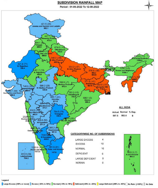
However, the six subdivisions covering Uttar Pradesh, Bihar, Jharkhand, Gangetic West Bengal, and Tripura are reeling under deficient rains. The east and northeastern part of India, on the whole, is staring at a deficit of 16%, which is likely to widen further in the coming week. Bihar alone faces a staggering deficit of 36%, east Uttar Pradesh at 46%, and west UP at 39%.
Read the Latest News and Breaking News here


Comments
0 comment